Hike on Thursday Morning
Good questions about the hike!
We will follow the original road of the transcontinental railroad bed. This
upper route was abandoned and the tracks and ties removed in the early 90s.
They graded the road and put down gravel at that time. Having said that, the
road has a slight downhill grade that looks and feels like a country road.
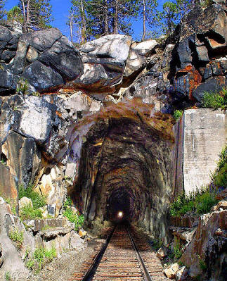
Because most of this road is underground or within snow sheds, there are
puddles of water you may step into. It is also pitch black in many parts of
the route, with occasional openings to step out and take in the gorgeous view.
The trail down from the old railroad grade to Donner Lake drops about 800 feet
in a mile and is very dusty. It actually looks and feels like an old logging
road. You and your shoes/boots will get very dusty. The length of the total
trip is about 6 miles. It is necessary to bring appropriate shoes for the
above, water and a good flashlight. Going on this trip without a light would
be very dangerous.
If the Rockford"s have laces they would be ok. The Nike's would also be good.
I would not recommend slip on shoes or wearing shoes without socks.
Having said all of this, they are going to get very dusty, and maybe wet, so
let that be your guide.
Tom
Mike and Jim:
The hike through the railroad tunnel and the snow sheds is a very interesting view of one of the key elements of the opening of the west. I have attached a short description from Wikipedia.
We will go through not only the Summit Tunnel, but also over a mile of the snow sheds.
The hike is about 6 miles long, and follows the railroad grade down to a valley above Donner lake where it turns on to a logging road. It is all down hill. This trip drops about 1,000 feet in the 6 miles.
Everyone needs to have a very good flashlight as we will be underground or in the dark snow sheds for over a mile and a half. It is also pretty cool, so a windbreaker that can be added is necessary.
The views are spectacular from the gaps between the tunnels and snow sheds, and there are some openings in the sheds that let you go out onto areas that overlook the cliffs and the valley.
We plan to do this hike while the golfers are in the tournament.
Tom
Railroad & Donner Pass
In the spring of 1868, the Sierra Nevada were finally "conquered" by the Central Pacific Railroad after almost five years of sustained construction effort with the successful completion at Donner Pass of its 1,659-foot (506 m) Tunnel #6 (aka the Summit Tunnel) and associated grade thus permitting the establishment of commercial transportation en masse of passengers and freight over the Sierras for the first time. Following a route first surveyed and proposed by the CPRR's original Chief Engineer, Theodore D. Judah (1826-1863), the construction of the four tunnels, several miles of snowsheds, and two "Chinese Walls" necessary to breach Donner Summit constituted by far the most difficult engineering and construction challenge of the entire original Sacramento to Ogden CPRR route.
CPRR Engineers L.M. Clement & T.D. Judah
Principally designed and built under the personal, often on-site direction of the CPRR's Chief Assistant Engineer, Lewis M. Clement (1837-1914), the original (Track #1) summit grade remained in continuous daily use from June 18, 1868, when the first CPRR passenger train ran through the Summit Tunnel, until 1993 when the Southern Pacific Railroad (which operated the CPRR-built Oakland-Ogden line until its 1996 merger with the Union Pacific Railroad) abandoned and pulled up the 6.7 mile (10.7 km) section of Track #1 over the summit running between Shed #41 at Norden (MP 192.1) and the covered crossovers in Shed #47 (MP 198.8) located about a mile East of the old flyover at Eder. Since then all East and Westbound traffic has been run over the Track #2 grade crossing the summit about one mile (1.6 km) south of Donner Pass through the 10,322-foot (3,146 m) long Tunnel #41 (aka "The Big Hole") running under Mt. Judah between Soda Springs and Eder. Then operator SPRR made this change because the railroad considered Track #2 and Tunnel #41 (which was opened in 1925 when the summit section of the grade was finally double tracked) to be far easier and less expensive to maintain and keep open in the harsh Sierra winters than the Track #1 tunnels and snow sheds over the summit.[1]
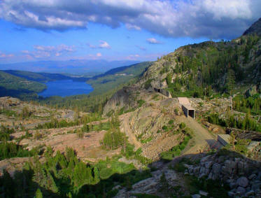
Donner Lake (left) and the now abandoned original CPRR (later SPRR; UPRR) Track #1 grade over Donner Pass.
In conjunction with major ongoing upgrades and expansions being made to the Port of Oakland in order to better accommodate the rapidly growing North American trade with Asia and the Pacific, the cooperation of the UPRR, the Port's principal rail partner, has been sought to "construct a second track and raise tunnel clearances over Donner Pass for container trains linking California with the rest of the country."[2] To accomplish this objective would likely require the UP to either drive a second parallel tunnel next to Tunnel #41, or to restore and reopen the summit section of Track #1 between Sheds #41 and #47. Either infrastructure upgrade would increase the route's overall capacity, considerably simplify traffic management, and effectively eliminate delays currently caused by having to run all east and west bound traffic between Norden and Eder over a single track. [To fully eliminate the grade's "bottleneck" delays the now single track 7.1-mile (11.4 km) section between Switch #9 (MP 171.9) and Shed #10 (MP 179.0) just west of Cisco would likely also have to be restored to double track.] Increasing tunnel and snow shed clearances on the Sierra grade would also permit the use of double-stacked container cars which now can only be run via the UP's Feather River grade.[3] It is not yet clear, however, when (or if) any of these proposed major infrastructure upgrades might become a reality.